
La version française suit
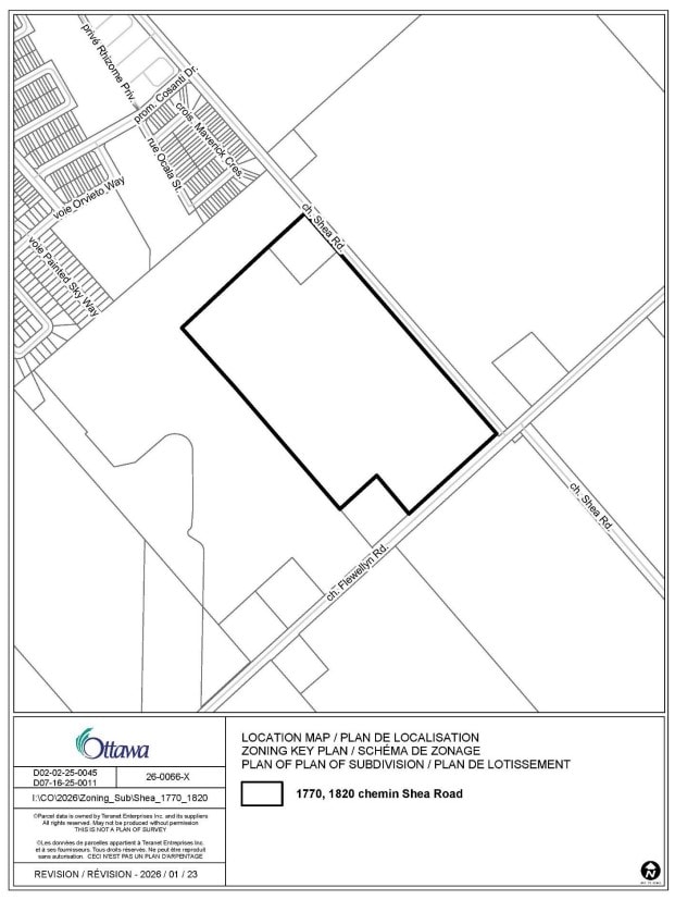
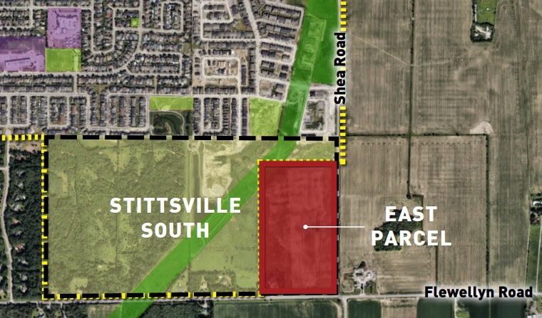
The City of Ottawa has received Plan of Subdivision and Zoning By-law Amendment applications for 1770 and 1820 Shea Road, located at the northwest corner of the intersection of Shea Road and Flewellyn Road.
The proposal from Caivan is for a residential subdivision that would include a mix of detached homes and townhomes for a total of 360 homes, a new municipal park, a stormwater management facility, and a block reserved for the Faulkner Municipal Drain and its environmental protection buffer.
This land is located entirely within Ward 21 (Rideau-Jock) but given its proximity to Ward 6 (Stittsville) we’re sharing this update for Stittsville residents.
More information about the proposal is available on the City’s DevApps site:
Background
These lands are currently located outside of the City’s Urban Boundary. A separate Official Plan Amendment application for an Urban Boundary Expansion is currently under review and proposes to add the lands in the City’s Urban Boundary and re-designate it to “Neighbourhood” under the Suburban Transect. (See below under “What’s next” for more information.)
West of the site is the Stittsville South Urban Expansion Area (W-4), which was previously included in the Urban Boundary as a new growth area. This area has a recently approved concept plan guiding the future development of the lands, to permit a residential subdivision with approximately 1,700 dwelling units.
While applications for 1770 and 1820 Shea Road are independent from the Stittsville South Urban Expansion Area (W-4), the concept planning for those lands included consideration for these parcels.
Plan of Subdivision
The applicant is proposing a new low-rise residential subdivision consisting of approximately 360 low-rise, low-density homes. The subdivision also proposes a municipal park, stormwater management facility, and municipal drain block. The proposal includes new local roads, with a connection to Shea Road and the abutting Magnolia (Stittsville South) subdivision.
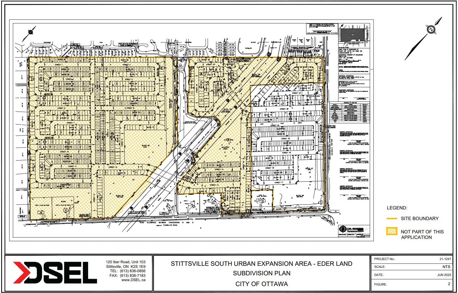
Plan of Subdivision (includes Stittsville South W-4)
Zoning By-law Amendment
A zoning by-law amendment application has been submitted to accommodate the proposed land uses for the plan of subdivision. The subject lands are currently zoned Rural Countryside (RU). The application seeks to rezone the lands as follows:
- R3YY[XXXX] – Residential Third Density, Subzone YY, with an Urban Exception, to permit low-rise residential uses and address site-specific exceptions
- O1 – Open Space Zone, for the Hydro Corridor, stormwater management facility (pond), and park
What’s next
This development has not been approved. The Official Plan Urban Boundary Expansion to add the subject lands to the City’s Urban Boundary is a pre-requisite to the plan of subdivision and zoning by-law amendment applications. A decision will not be rendered on the two applications unless the lands are approved for inclusion into the City’s Urban Boundary.
City staff are reviewing the proposal, as are the Councillor and his team.
Stay informed and provide feedback
Register for future notifications about this application and provide your comments by contacting Stream Shen at 613-580-2424, ext. 24488 or stream.shen@ottawa.ca and including File No. D07-16-25-0011 & D02-02-25-0045 in the subject line. You can copy Councillor Glen at glen.gower@ottawa.ca.
Deadline for comments is February 25, 2026. Please note, comments will continue to be accepted and considered after the initial comment period due date noted above. However, comments received after the above date may not be reflected in the staff report.
1770 et 1820, chemin Shea : Demandes d’approbation du plan de lotissement et de modification du Règlement de zonage
La Ville d’Ottawa a reçu une demande d’approbation du plan de lotissement et une demande de modification du Règlement de zonage pour les terrains situés aux 1770 et 1820, chemin Shea, à l’angle nord-ouest de l’intersection des chemins Shea et Flewellyn.
Le projet prévoit l’aménagement d’un lotissement résidentiel comprenant un mélange de maisons individuelles et en rangée, pour un total de 360 habitations, ainsi qu’un nouveau parc municipal, une installation de gestion des eaux pluviales et un îlot réservé au drain municipal Faulkner et à sa zone tampon de protection environnementale.
Ces terrains se trouvent entièrement dans le quartier 21 (Rideau-Jock), mais compte tenu de leur proximité avec le quartier 6 (Stittsville), le présent bulletin d’information est également transmis aux résidentes et résidents de Stittsville.
Pour en savoir plus sur le projet, consultez la page de la Ville consacrée aux demandes d’aménagement :
Contexte
Les terrains visés se trouvent actuellement à l’extérieur des limites du secteur urbain de la ville. Une demande de modification du Plan officiel distincte, visant à élargir ces limites, est en cours d’examen. Elle propose d’intégrer ces terrains au secteur urbain et de les désigner comme « quartiers » du transect du secteur de banlieue. (Pour en savoir plus, reportez-vous à la section « Prochaines étapes » ci-dessous.)
À l’ouest de l’emplacement se trouve la zone d’expansion urbaine de Stittsville-Sud (W-4), qui a été intégrée aux limites du secteur urbain comme nouvelle zone de croissance. Cette zone fait l’objet d’un plan conceptuel d’aménagement futur récemment approuvé qui permettra la création d’un lotissement résidentiel comptant environ 1 700 logements.
Bien que les demandes relatives aux 1770 et 1820, chemin Shea ne concernent pas la zone d’expansion urbaine de Stittsville-Sud (W-4), ces parcelles ont été prises en compte dans la planification conceptuelle.
Plan de lotissement
Le requérant propose d’aménager un lotissement résidentiel comprenant environ 360 habitations de faible hauteur et de faible densité, un parc municipal, une installation de gestion des eaux pluviales et un îlot pour le drain municipal. Le projet prévoit également de nouvelles routes locales avec un accès au chemin Shea et au lotissement Magnolia voisin (Stittsville-Sud).
Plan de lotissement (comprenant la zone de Stittsville-Sud W-4)
Modification du Règlement de zonage
Une demande de modification du Règlement de zonage a été déposée pour autoriser les utilisations du sol proposées. Elle vise à modifier le zonage des terrains visés, qui appartiennent actuellement à la zone d’espace rural (RU), comme suit :
- R3YY [XXXX] – Zone résidentielle de densité 3, sous-zone YY, exception urbaine, pour permettre l’aménagement d’habitations de faible hauteur et prévoir des exceptions propres à l’emplacement.
- O1 – Zone d’espace ouvert, pour le couloir de transport d’électricité, l’installation de gestion des eaux pluviales (étang) et le parc.
Prochaines étapes
Ce projet n’a pas encore été approuvé. Les terrains visés doivent d’abord être intégrés aux limites du secteur urbain du Plan officiel pour que la Ville puisse examiner les demandes d’approbation du plan de lotissement et de modification du Règlement de zonage. Aucune décision ne sera rendue concernant ces deux demandes tant que l’élargissement des limites du secteur urbain n’aura pas été approuvé.
Le personnel de la Ville examine actuellement la proposition, tout comme le conseiller et son équipe.
Renseignements et commentaires
Pour recevoir les prochains avis sur ces demandes ou transmettre vos commentaires, communiquez avec Stream Shen au 613-580-2424, poste 24488 ou à stream.shen@ottawa.ca en indiquant « Dossiers nos D07-16-25-0011 et D02-02-25-0045 » en objet. Vous pouvez aussi mettre en copie conforme le conseiller Glen Gower (glen.gower@ottawa.ca).
Vous avez jusqu’au 25 février 2026 pour formuler des commentaires. Les commentaires reçus après cette date seront acceptés et examinés, mais ne seront pas nécessairement pris en compte dans le rapport du personnel.