
La version française suit
(This post is adapted from an update that was originally published on my Substack newsletter.)
Late last fall, the provincial government announced plans to consolidate Ontario’s 36 conservation authorities (CAs) down to seven.
For the Ottawa area, the province proposed merging the three CAs in our region1 with two others, creating a massive eastern regional authority spanning two major rivers (the Ottawa and the St. Lawrence).
Many municipalities across Ontario passed motions raising major concerns — and sometimes outright opposition to — the proposal. Ottawa City Council, among other resolutions, called on the province “to maintain local, municipally-governed, watershed-based Conservation Authorities to ensure effective natural resource and hazard management, transparent local services, bilingualism obligations, and accountability over municipal levy dollars…”
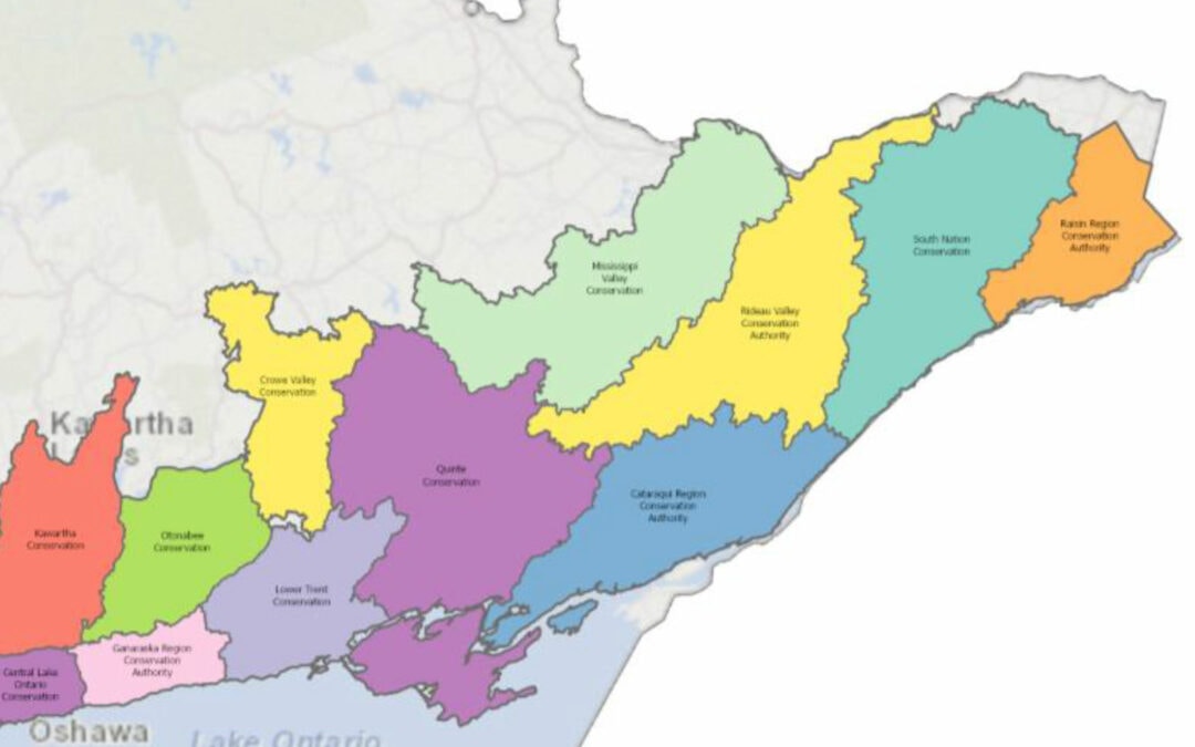
(The Conservation Authorities are each governed by a board of directors made up of councillors who represent the municipalities covered by the watershed. For example, I’m one of four Ottawa Council representatives on the Mississippi Valley Conservation Authority board, which covers an area from the Carp River in Kanata–Stittsville to Upper Mazinaw Lake near Bon Echo Park.)
A group of 74 watershed professionals wrote a letter to the Premier and several Ministers urging “care and caution” and stating that “the proposed restructuring appears to lack an evidence-based approach and business case”. The letter includes 16 recommendations on how the province could proceed.
Those experts are right to be concerned. Messing around with the governance and staff at conservation authorities comes with a high level of risk and should not be taken lightly.
- CAs play an important role in managing and preventing floods. That’s top of mind for me right now as we enter the spring freshet season.
- CAs play a key role in monitoring and maintaining clean drinking water, by protecting and improving the quality of water sources.
- Collectively, Ontario’s CAs own and manage over 150,000 hectares of natural areas used for conservation, recreation, flood and erosion control.
***
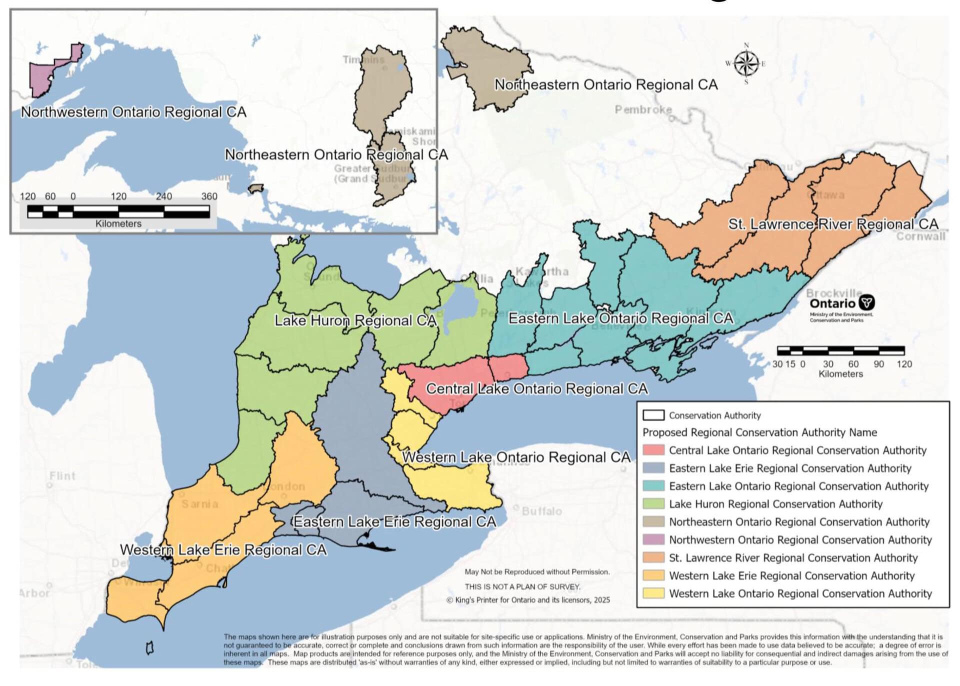
On Tuesday, the provincial government announced revised plans to consolidate the 36 CAs down to nine (instead of seven), along with other changes to what was originally proposed in the fall. They’re targeting February 2027 to complete the mergers. A few other things that stood out to me in the update yesterday:
- The governance still isn’t clear to me. The province says the CAs will remain independent organizations – presumably this means independent from the province, even though they sit under a new Ontario Provincial Conser vation Agency. It’s not clear how this governance would function. And provincial officials emphasized that the new CAs will maintain municipal governance. But only cities and counties will have representation on the management boards. Lower tier municipalities (towns and townships) will be cut out. And a single board will now be managing an organization responsible for a much larger geography.
- CAs will still continue to manage land that they own, including conservation areas.
- The CAs will establish new “watershed councils” to “help identify local priorities for watershed-based conservation programs and services”.
- I’m not a fan of the name they’ve assigned to the Ottawa region CA – “St. Lawrence River Regional CA”. It’s a bit of a misnomer, given that most of the watershed rivers flow to the Ottawa River: Mississippi, Carp, Rideau, and South Nation. Only the Raisin River flows directly into the St. Lawrence. (Although I suppose the Ottawa eventually drains into the St. Lawrence?)
More info:
- Media Backgrounder: Improving Ontario’s Conservation Authority System (PDF)
- Ontario Nature advocacy on conservation authorities
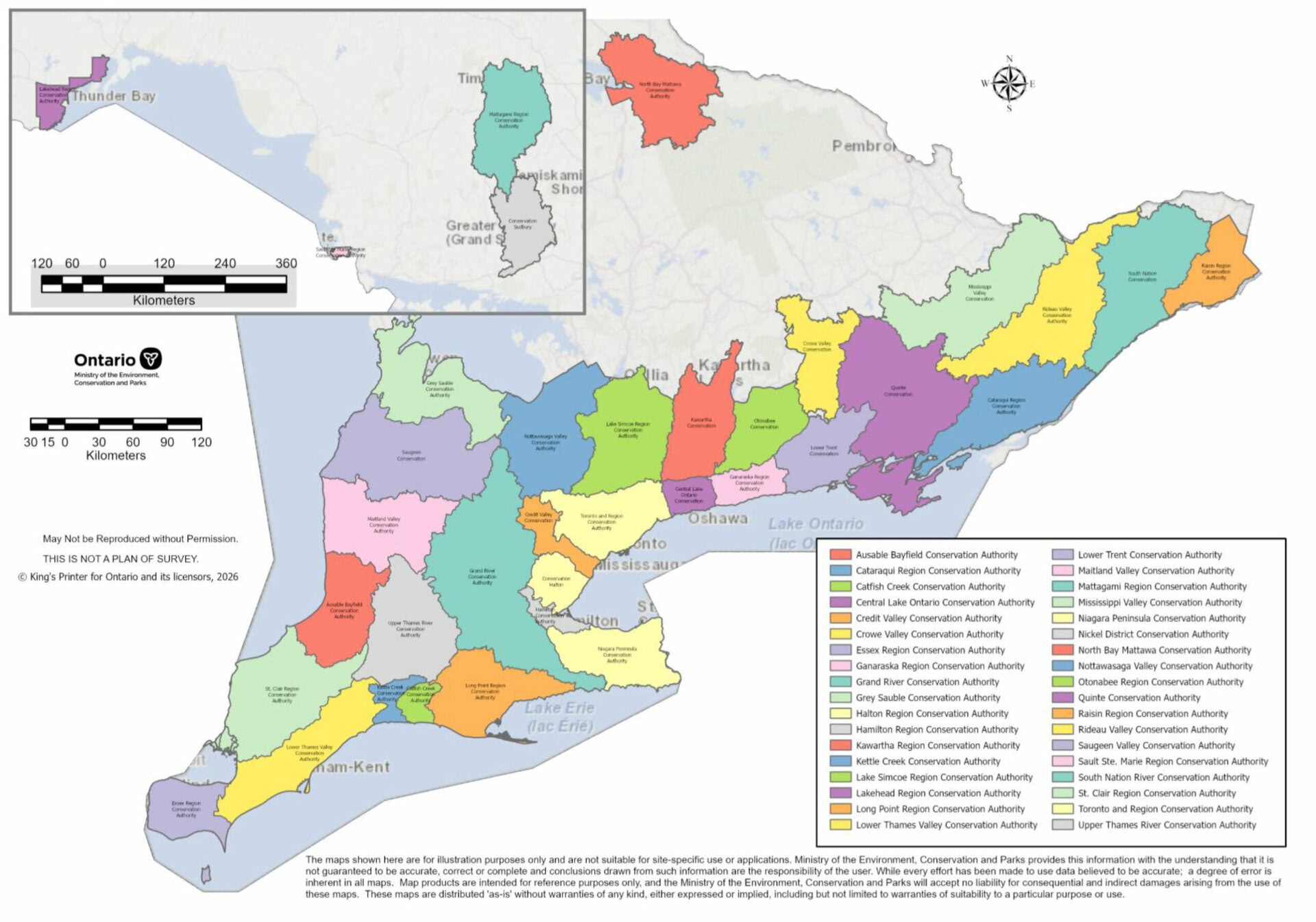
Existing Conservation Authorities in Ontario
CARNET DE NOTES : Le plan de fusion des offices de protection de la nature soulève d’importantes préoccupations
(Publication adaptée d’une mise à jour publiée sur mon bulletin d’information Substack*.)
À la fin de l’automne, le gouvernement provincial a annoncé qu’il comptait fusionner les offices de protection de la nature de l’Ontario* pour passer de 36 à 7 entités.
Pour notre région, la province a proposé de fusionner les trois offices de protection de la nature d’Ottawa1* avec deux autres, ce qui donnerait un vaste office pour la région de l’Est couvrant deux importants cours d’eau : la rivière des Outaouais et le fleuve Saint-Laurent.
De nombreuses municipalités ontariennes ont adopté des motions exprimant de sérieuses réserves face à cette proposition, voire une opposition franche. Le Conseil municipal d’Ottawa a notamment demandé à la province de maintenir des offices de protection de la nature locaux, qui relèvent des municipalités et qui sont établis en fonction des bassins versants, pour assurer une gestion efficace des ressources naturelles et des risques, la transparence des services locaux, le respect des obligations en matière de bilinguisme et une utilisation responsable des fonds municipaux.
(Les offices de protection de la nature sont dirigés par un conseil d’administration auquel siègent des conseillères et conseillers des municipalités situées sur le territoire du bassin versant. Par exemple, je fais partie des quatre personnes représentant le Conseil municipal nommées au conseil d’administration de l’Office de protection de la nature de la vallée Mississippi, dont le territoire va de la rivière Carp, à Kanata–Stittsville, jusqu’au lac haut Mazinaw, près du parc Bon Echo.)
Un groupe de 74 spécialistes des bassins versants a adressé une lettre* au premier ministre et à plusieurs ministres pour les exhorter à faire preuve de prudence et de discernement et souligner que « le projet de restructuration ne semble reposer ni sur une démarche fondée sur des données probantes ni sur un dossier de décision étoffé » (traduction libre). La lettre présente 16 recommandations que la province pourrait envisager pour la suite*.
Ces spécialistes ont raison de s’inquiéter. S’ingérer dans la gouvernance et le personnel des offices de protection de la nature pose des risques notables et appelle une réflexion attentive.
- Les offices jouent un rôle important dans la gestion et la prévention des inondations. Il s’agit pour moi d’une priorité en ce moment, à l’approche de la crue printanière*.
- Ils sont également essentiels à la surveillance et à la protection de l’eau potable, puisqu’ils veillent à préserver les sources d’approvisionnement et à en améliorer la qualité.
- Collectivement, ces entités possèdent et gèrent plus de 150 000 hectares de milieux naturels consacrés à la conservation, aux activités récréatives, au contrôle des inondations et à la lutte contre l’érosion.
***
Mardi, le gouvernement provincial a annoncé des révisions à son plan, qui prévoit maintenant la fusion des 36 offices en 9 entités* (plutôt qu’en 7) et d’autres modifications par rapport à ce qui avait été présenté à l’automne. Il souhaite que la fusion soit terminée d’ici février 2027. Voici quelques autres éléments qui ont retenu mon attention :
- La question de la gouvernance demeure nébuleuse pour moi. Le gouvernement affirme que les offices resteront des organismes indépendants. On peut présumer que cette intention fait référence à une indépendance du gouvernement provincial, même si les entités relèveraient d’une nouvelle mouture de l’Agence ontarienne de conservation de la nature. Tout cela manque de clarté. Les responsables provinciaux ont aussi insisté sur le fait que la gouvernance des nouvelles entités demeurerait dans le giron municipal. Or, seules des personnes représentant des municipalités et des comtés siégeraient aux conseils d’administration, ce qui signifie que les échelons inférieurs de la structure (villes et cantons) seraient laissés de côté. En outre, un seul conseil serait désormais responsable d’une organisation gérant un très grand territoire.
- Les offices continueront de gérer les terres qu’ils possèdent, y compris les zones de conservation.
- Ils devront créer de nouveaux « conseils locaux sur les bassins versants, qui aiderai[ent] à cerner les priorités locales pour les programmes et services de protection de la nature ».
- J’ai des réserves quant au nom retenu pour l’office de la région d’Ottawa, l’Office de protection de la nature régional du fleuve Saint‑Laurent, qui me semble mal choisi. En effet, la majorité des rivières du bassin versant (Mississippi, Carp, Rideau et Nation) se jettent dans la rivière des Outaouais. Seule la rivière Raisin se déverse directement dans le Saint‑Laurent. (Il est vrai que la rivière des Outaouais finit par rejoindre le Saint‑Laurent, mais tout de même.)
Plus d’info
- Document d’information pour les médias : Amélioration du système des offices de protection de la nature de l’Ontario
- Travail de défense d’Ontario Nature à propos des offices de protection de la nature*
Offices de protection de la nature existant actuellement en Ontario