

Originally published August 14, 2024
La version française suit
(Photo by Barry Gray.)
There’s no sugarcoating it: Stittsville Main Street is not a safe street for cycling.
A couple of years ago, Ottawa City Council approved a new Public Realm Plan for Stittsville Main that will see major improvements to cycling infrastructure on the street, including multi-use pathways (MUPs) on both sides. Stittsville Main Street upgrades are included in the Transportation Master Plan coming to committee and council in the next month, which will allow us to secure funding for the work. In the meantime, we’re stuck with a street designed in the early 1990s that left cycling as an afterthought.
I use my bike to get around the community and I try to avoid Stittsville Main as much as possible. I use parallel roads and connecting pathways instead. I’ve put this map together to show some of the north-south alternatives that you can use to bypass Stittsville Main Street.
–Councillor Glen
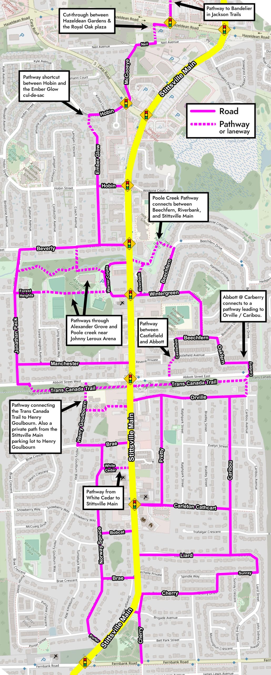
Click map for larger size
Voies cyclables de rechange pour la rue Stittsville Main
(Photo par Barry Gray)
Il n’y a pas à dire : La rue Stittsville Main n’est pas sécuritaire pour les cyclistes.
Il y a quelques années, le Conseil municipal d’Ottawa a approuvé un nouveau plan du domaine public pour la rue Stittsville Main, lequel prévoit d’importantes améliorations de l’infrastructure cyclable de la rue, y compris des sentiers polyvalents des deux côtés de celle-ci. Les améliorations de la rue Stittsville Main sont incluses au Plan directeur des transports, qui sera soumis aux comités et au Conseil le mois prochain, ce qui nous permettra d’obtenir du financement pour les travaux. En attendant, nous sommes coincés avec une rue conçue au début des années 1990 qui ne tient pas compte des cyclistes.
J’utilise mon vélo pour me déplacer dans la communauté et j’essaie d’éviter la rue Stittsville Main autant que possible. J’utilise plutôt des routes parallèles et des sentiers connexes. J’ai créé cette carte pour montrer quelques-unes des voies de rechange nord-sud que vous pouvez utiliser pour éviter la rue Stittsville Main.
– Glen Gower, conseiller
| Cut-through between Hazeldean Gardens & the Royal Oak plaza | Passage par Hazeldean Gardens et le centre commercial Royal Oak |
| Pathway to Bandelier in Jackson Trails | Chemin traversant Jackson Trails pour rejoindre la voie Bandelier |
| Poole Creek Pathway connects between Beechfern, Riverbank, and Stittsville Main | Le sentier du ruisseau Poole relie la promenade Beechfern, la cour Riverbank et la rue Stittsville Main |
| Abbott @ Carberry connects to a pathway leading to Orville / Caribou. | La rue Abbott à la hauteur de la promenade Carberry est reliée à un sentier menant à Orville/Caribou. |
| Pathways through Alexander Grove and Poole creek near Johnny Leroux Arena | Sentiers à travers le parc Alexander-Grove et le ruisseau Poole près de l’Aréna Johnny-Leroux |
| Pathway between Castlefield and Abbott | Sentier entre l’avenue Castlefield et la rue Abbott |
| Pathway from White Cedar to Stittsville Main | Sentier de la rue White Cedar à la rue Stittsville Main |
| Pathway connecting the Trans Canada Trail to Henry Goulbourn. Also a private path from the Stittsville Main parking lot to Henry Goulbourn | Sentier reliant le Sentier transcanadien à la rue Henry-Goulbourn. Un sentier privé du parc de stationnement de Stittsville Main à la rue Henry-Goulbourn |
| Pathway shortcut between Hobin and the Ember Glow cul-de-sac | Raccourci entre la rue Hobin et le cul-de-sac Ember Glow |