
La version française suit
A City report that I always look forward to is the Greenfield Residential Land Survey*. It’s a yearly report that gives a point-in-time snapshot of vacant land that has been designated for future development in suburban Ottawa, including Stittsville. The report outlines trends in recent development, and gives us some idea of what’s likely to come in future years.
(*Greenfield = Land that is undeveloped within Ottawa’s urban boundary as of July 1, 2018, as well as land added by expanding the City’s urban boundary. Almost all of it is located in the suburbs.)
The provincial government requires cities to have a 15-year supply of residential land to accommodate future growth, including a three-year supply of serviced land (with water and sewer) that are draft approved and ready to build on. For Ottawa, a 15-year housing supply would be enough for an estimated 47,859 homes, or 1,268 hectares of land.
As of July 1, 2024, Ottawa had 1,582 hectares of designated greenfield land. Of that land, 1210 hectares are serviced (they have water and wastewater servicing capacity); and 620 hectares are either draft approved or registered. Overall, that’s enough land to accommodate an estimated 69,736 homes in the next 15 years, far exceeding the provincial target.
The report also highlights:
- From mid-2023 to mid-2024, greenfield residential land consumption totaled 59.2 hectares, and construction started on 2,527 dwellings, the lowest amount in five years.
- The average development density surveyed was 42.7 units per net hectare, higher than the five-year average of 39.8 units per net hectare.
- From mid-2019 to mid-2024, fewer dwellings started construction on greenfield lands than projected in the Official Plan. The Official Plan projected over 22,500 housing starts, but we only saw 19,510.
- You can download the full reports and maps here…
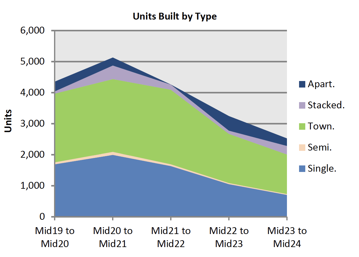
Housing types
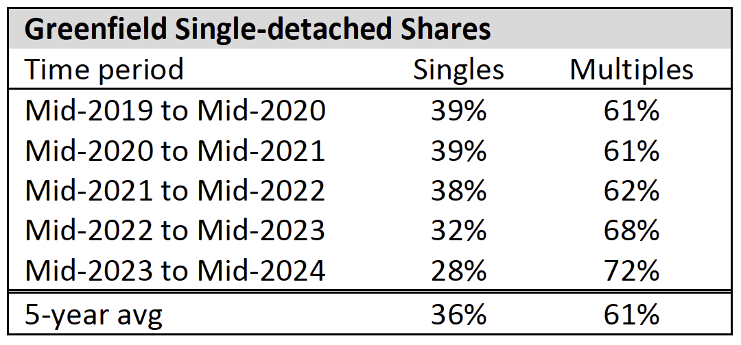
Data from the report shows an overall decline in units being built, and a continuing decline in the share of single-detached homes being built.
Stittsville-specific development
- The report groups Stittsville in with Kanata. Between mid-2019 and mid-2024, Kanata and Stittsville accounted for an average of 1,128 new greenfield housing starts per year, or 28.9% of Ottawa’s total.
- There is 431 hectares of greenfield land supply in Kanata-Stittsville, representing a potential 19,447 homes.
- Although the report doesn’t break out Stittsville specifically, based on our analysis of the report data we estimate that there are 238 hectares of greenfield land supply in Stittsville, representing a potential 11,248 homes.
- It’s hard to say how many years it will take before all of that land is built on, but based on recent housing starts it’s at least 15-20 years of land supply, and it could very well be more.
Here’s a map showing all of the future development parcels, along with the stage of development. A table showing the landowner, parcel size, and development status is included below. Much of the current and future development continues to be in the wedge of land between the Village of Stittsville and Kanata. That stems from a decision by the Ontario Municipal Board in the mid-2000’s to allow development in this former farmland, over the wishes of City Council.
Remember, this is a snapshot from mid-2024 so some of these parcels have advanced through the various stages of planning and development. (See also: What’s the latest on Stittsville residential development files? July 2025)
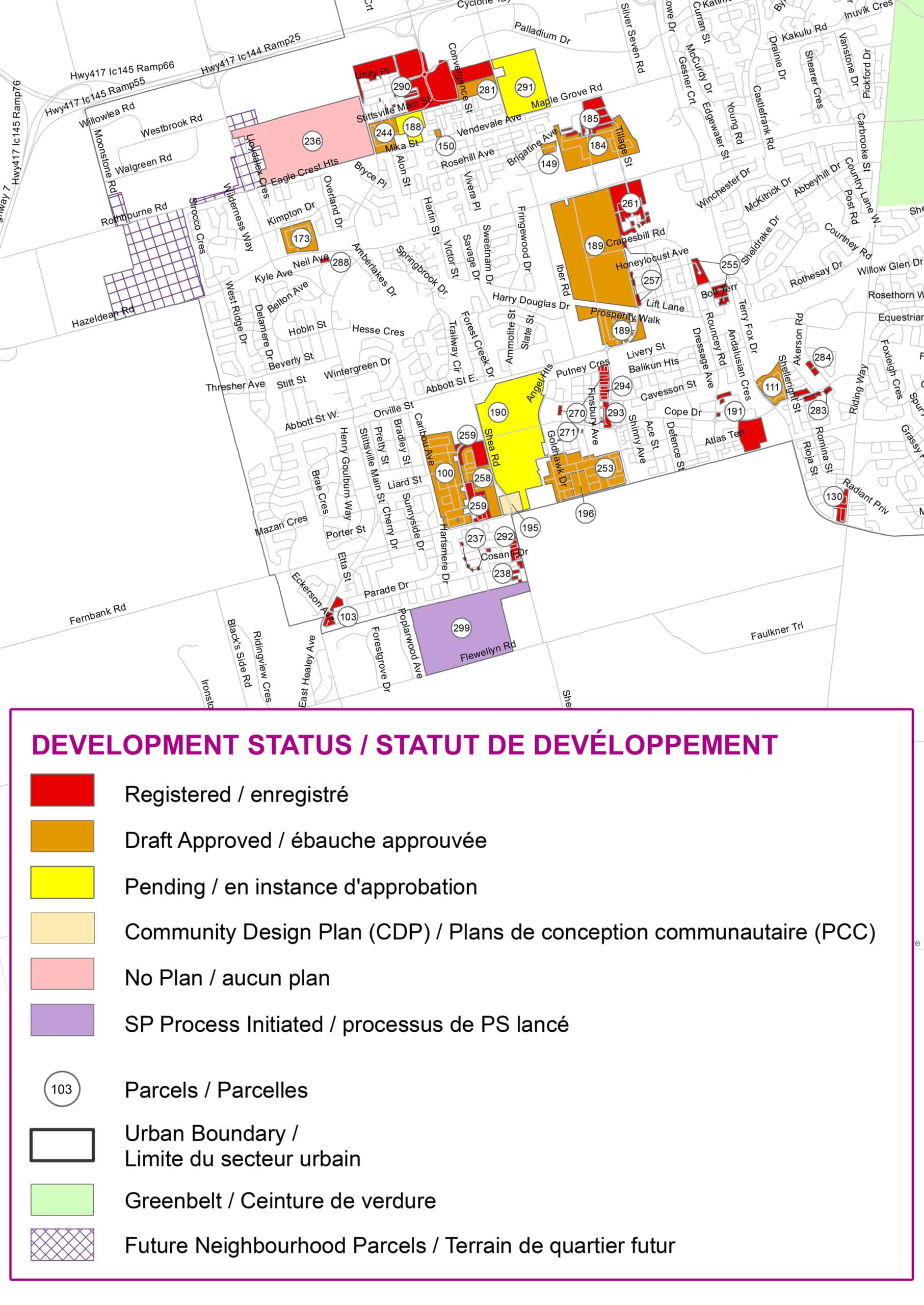
Map showing Stittsville land development status as of mid-2024. Click for full size.
| Parcel Number | Land owner | Parcel size (ha) | Total unit potential | Development Status |
| 100 | 2087875 Ontario Ltd | 18.14 | 562 | DA |
| 103 | Mattamy | 0.91 | 130 | RG |
| 149 | Mattamy | 1.06 | 47 | DA |
| 150 | Maple Way Inc. | 0.40 | 18 | DA |
| 173 | 11654128 Canada Inc | 5.69 | 570 | DA |
| 184 | Richcraft | 9.52 | 515 | DA |
| 185 | Richcraft | 3.48 | 120 | RG |
| 188 | Formasian Development Corp | 4.42 | 524 | PG |
| 189 | Minto | 49.60 | 2,703 | DA |
| 190 | CRT Development Inc | 17.03 | 610 | PG |
| 191 | Mattamy | 0.78 | 21 | RG |
| 195 | Dahavland Capital | 2.22 | 60 | CDP |
| 196 | Fernbank Stone Dev | 2.82 | 70 | DA |
| 236 | M & A Rentals | 38.20 | 1,493 | NP |
| 237 | Davidson Co-Tenancy | 0.26 | 7 | RG |
| 238 | Davidson Co-Tenancy | 0.98 | 34 | RG |
| 244 | Claridge | 4.50 | 196 | DA |
| 253 | CRT Development Inc | 14.25 | 566 | DA |
| 255 | SPB Developments Inc | 3.56 | 134 | RG |
| 257 | Richcraft | 0.78 | 13 | RG |
| 258 | Cavanagh | 5.28 | 224 | DA |
| 259 | Cavanagh | 3.98 | 190 | RG |
| 261 | 2118356 Ontario Inc | 5.50 | 187 | RG |
| 270 | CRT | 2.20 | 115 | RG |
| 271 | CRT | 0.10 | 3 | RG |
| 281 | Lioness Developments Inc | 1.97 | 206 | DA |
| 288 | 2073945 Ontario Inc | 0.28 | 57 | RG |
| 290 | 2325483 Ontario Ltd | 2.45 | 161 | RG |
| 291 | Lioness Developments Inc | 13.58 | 753 | PG |
| 292 | Davidson Shea Properties Inc | 2.48 | 116 | RG |
| 293 | Richcraft | 1.60 | 84 | RG |
| 294 | Tamarack | 1.19 | 72 | RG |
| 299 | Caivan | 19.09 | 687 | SPPI |
| Totals | 238.3 ha | 11,248 homes |
CARNET DE NOTES : Stittsville — mise à jour sur les zones vertes résidentielles (milieu de 2024)
Un rapport de la Ville que j’attends toujours avec intérêt est l’Enquête sur les terrains résidentiels en zone verte*. Ce rapport, publié chaque année, dresse un portrait ponctuel des terrains vacants réservés à un développement futur dans les banlieues d’Ottawa, y compris à Stittsville. Le rapport présente les tendances récentes en matière de développement et nous donne une idée de ce qui pourrait survenir dans les prochaines années.
(*Zone verte : terrain non aménagé situé à l’intérieur de la limite urbaine d’Ottawa au 1er juillet 2018, ainsi que les terrains ajoutés lors de l’expansion subséquente de cette limite. La grande majorité de ces terrains se trouve dans les banlieues.)
Selon les exigences du gouvernement provincial, les municipalités doivent disposer d’un stock de terrains résidentiels suffisant pour 15 ans de croissance, y compris une réserve de trois ans en terrains viabilisés (munis de réseaux d’aqueduc et d’égouts) ayant obtenu une approbation préalable de projets d’aménagement de terrains et prêts à accueillir un projet de construction. Pour Ottawa, une réserve de 15 ans permettrait la construction estimée de 47 859 habitations, soit environ 1 268 hectares de terrains.
Au 1er juillet 2024, Ottawa comptait 1 582 hectares de terrains classés comme zones vertes. Sur cette superficie, 1 210 hectares sont viabilisés (dotés de la capacité en eau et en traitement des eaux usées), tandis que 620 hectares sont soit approuvés préalablement, soit enregistrés. Globalement, cela équivaut à une capacité d’environ 69 736 habitations au cours des 15 prochaines années, dépassant de beaucoup l’objectif établi par la province.
Le rapport souligne aussi les points suivants :
- Du milieu de 2023 au milieu de 2024, la consommation de zones vertes résidentielles a totalisé 59,2 hectares, et les mises en chantier ont porté sur 2 527 habitations, soit le niveau le plus faible en cinq ans.
- La densité moyenne de développement observée était de 42,7 unités par hectare net, une valeur supérieure à la moyenne quinquennale de 39,8 unités par hectare net.
- Du milieu de 2019 au milieu de 2024, le nombre de mises en chantier sur les zones vertes a été inférieur aux projections du Plan officiel. Le Plan officiel anticipait plus de 22 500 mises en chantier, mais seulement 19 510 se sont concrétisées.
- Cliquez sur ce lien pour télécharger les cartes et les rapports…
Types d’habitations
Les données du rapport indiquent une baisse générale du nombre d’unités construites, ainsi qu’une diminution constante de la proportion de maisons unifamiliales individuelles.
Développement propre à Stittsville
- Dans ce rapport, Stittsville est regroupé avec Kanata. Au cours de la période allant du milieu de 2019 au milieu de 2024, Kanata-Stittsville enregistrait en moyenne 1 128 nouvelles mises en chantier annuelles en zones vertes, ce qui représentait 28,9 % du total d’Ottawa.
- On dénombre 431 hectares de zones vertes dans Kanata-Stittsville, ce qui représente un potentiel d’environ 19 447 habitations.
- Bien que le rapport ne fournisse pas de données distinctes pour Stittsville, notre analyse estime qu’on y trouve environ 238 hectares de zones vertes, pouvant accueillir environ 11 248 habitations.
- Il est difficile de déterminer en combien d’années l’aménagement complet de ces terrains pourra se réaliser, mais selon les mises en chantier récentes, il s’agit d’un stock de terrains résidentiels suffisant pour au moins 15 à 20 ans, voire plus.
Voici une carte montrant l’ensemble des parcelles à aménager et l’étape de développement à laquelle elles se trouvent. Le tableau suivant indique le nom du propriétaire foncier, la taille des parcelles ainsi que l’état d’avancement du développement. Une part importante du développement, tant actuel que futur, se situe dans la zone entre le village de Stittsville et Kanata. Cette situation résulte d’une décision rendue par la Commission des affaires municipales de l’Ontario au milieu des années 2000, autorisant l’aménagement de ces anciennes terres agricoles malgré l’opposition du Conseil municipal.
Rappelons que ce portrait date du milieu de 2024, et que certaines de ces parcelles à aménager ont déjà franchi des étapes supplémentaires de planification et de développement. (Voir également : Où en sont les dossiers d’aménagements résidentiels à Stittsville? (Juillet 2025)
Carte montrant l’état d’avancement du développement foncier à Stittsville à la mi-2024. Cliquez pour agrandir.
| Numéro de parcelle | Propriétaire foncier | Superficie de la parcelle (ha) | Potentiel total d’unités | État d’avancement du développement | |
| 100 | 2087875 Ontario Ltd | 18.14 | 562 | DA | |
| 103 | Mattamy | 0.91 | 130 | RG | |
| 149 | Mattamy | 1.06 | 47 | DA | |
| 150 | Maple Way Inc. | 0.40 | 18 | DA | |
| 173 | 11654128 Canada Inc | 5.69 | 570 | DA | |
| 184 | Richcraft | 9.52 | 515 | DA | |
| 185 | Richcraft | 3.48 | 120 | RG | |
| 188 | Formasian Development Corp | 4.42 | 524 | PG | |
| 189 | Minto | 49.60 | 2,703 | DA | |
| 190 | CRT Development Inc | 17.03 | 610 | PG | |
| 191 | Mattamy | 0.78 | 21 | RG | |
| 195 | Dahavland Capital | 2.22 | 60 | CDP | |
| 196 | Fernbank Stone Dev | 2.82 | 70 | DA | |
| 236 | M & A Rentals | 38.20 | 1,493 | NP | |
| 237 | Davidson Co-Tenancy | 0.26 | 7 | RG | |
| 238 | Davidson Co-Tenancy | 0.98 | 34 | RG | |
| 244 | Claridge | 4.50 | 196 | DA | |
| 253 | CRT Development Inc | 14.25 | 566 | DA | |
| 255 | SPB Developments Inc | 3.56 | 134 | RG | |
| 257 | Richcraft | 0.78 | 13 | RG | |
| 258 | Cavanagh | 5.28 | 224 | DA | |
| 259 | Cavanagh | 3.98 | 190 | RG | |
| 261 | 2118356 Ontario Inc | 5.50 | 187 | RG | |
| 270 | CRT | 2.20 | 115 | RG | |
| 271 | CRT | 0.10 | 3 | RG | |
| 281 | Lioness Developments Inc | 1.97 | 206 | DA | |
| 288 | 2073945 Ontario Inc | 0.28 | 57 | RG | |
| 290 | 2325483 Ontario Ltd | 2.45 | 161 | RG | |
| 291 | Lioness Developments Inc | 13.58 | 753 | PG | |
| 292 | Davidson Shea Properties Inc | 2.48 | 116 | RG | |
| 293 | Richcraft | 1.60 | 84 | RG | |
| 294 | Tamarack | 1.19 | 72 | RG | |
| 299 | Caivan | 19.09 | 687 | SPPI | |
|
Totaux |
238.3 ha | 11,248 maisons |